Press releases
Belarus’ National Library receives copy of Radziwill map from Netherlands
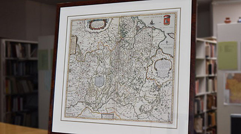
 MINSK, 17 May (BelTA) - The National Library of Belarus has received a facsimile copy of the map Magni Ducatus Lithuanie, et Regionum Adiacentium exacta Descriptio (1648) as a gift from the Royal National Library of the Netherlands, BelTA learned from the National Library of Belarus.
The title of the map, in translation from Latin, means: "The Grand Duchy of Lithuania and the Surrounding Regions with Their Exact Description”. This is one of the later versions of the famous Radziwill’s map made by Tomasz Makowski (1575 – circa 1630), a printer, artist and engraver at the court of Prince Radziwill in Nesvizh, and Hessel Gerritz (1581–1632), a Dutch engraver and cartographer of Blaeu’s publishing house in Amsterdam.
Created by the order of Prince Nicholas Christopher Radziwill nicknamed the Orphan (1549–1616), the map was first published in Amsterdam in 1613 by the famous publisher Willem Jansz Blaeu (1571–1638).
A cartouche, which decorates the top of the 1648 map, contains practically the same information that was displayed in the first edition of 1613. It is supplemented only with the publisher’s name, cartographer and publisher Johannes Blaeu (1596–1673) who headed the publishing house after the death of his father, Willem Blaeu, and became the official cartographer of the Dutch East India Company.


 print version
 make home page
 add to bookmarks

